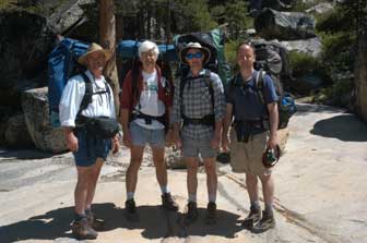
 Trek down the Grand Canyon of the Tuolumne: Trekkers include Jason Shaeffer, Jim Schuyler, Jeff Goldsmith, and Clark Quinn.
Trek down the Grand Canyon of the Tuolumne: Trekkers include Jason Shaeffer, Jim Schuyler, Jeff Goldsmith, and Clark Quinn.
We had planned a "short warm-up" for the first summer trip to Yosemite, and that's what we got. Frequently Tioga Pass Road, which gets us to the trailhead, isn't even open by June 11th, but this year it was. We left San Francisco at 5:00am on a Friday morning, picking up our team on the way. Arrived at the trailhead around noon.
The Tuolumne River (right, with the Cathedral Range of mountains in the background) was running at its seasonal high, as snow is still melting everywhere above 9,000 feet. You can see the peaks are still snow-capped all around. The river is placid and smooth here. We take a gentle downhill walk of about 7 miles past the Glen Aulin 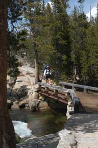 area as our first day hike. The trail passes over a couple of wooden bridges, and descends about 1,000 feet the first day. We camp about a mile past Glen Aulin where the Tuolumne river begins to form a narrow canyon. There are meadows along one side of the canyon, forming spots to camp between the canyon wall and the river. The rangers have warned us that the bears have learned new tricks this year - that they'll pup up on you when you're fixing dinner and scare you away so they can get your grub. We practice "leave no trace" camping, which means we carry out everything we carry in. We do not build campfires, but use small portable gas-burning stoves. Our food is dehydrated, in packets, and is carried inside a rugged plastic container that looks like a big black can. As long as the bear can is closed, the bear can't get into it. Period. We leave the bear cans about 100 feet away from our tents overnight so that curious bears can inspect them, though they don't even try to open them because they've learned that the cans are impenetrable. To make a long story short, we didn't see a bear on the whole trip, so I guess we were successful.
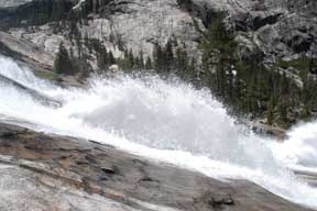
Where the first day on the trail had been short, the second day was spectacular and long. We breezed downhill, and by lunch time had passed California Falls, Le Conte Falls, and arrived at Waterwheel Falls. The scooped-out granite in the bed of the river causes the water to bloom spectacularly upward in gushing flows somewhat reminiscent of waterwheels. The river really thunders at this point in its descent down the canyon. The granite of the riverside has been scraped by glaciers and polished by thousands of years of water flow. Shooting photos of the waterwheels is a bit of a challenge - the water's moving fast, and three of us have electronic cameras, so we work at it and get some spectacular photos.
 This part of the journey is still heavily populated, as hikers can reach Waterwheel Falls on foot in a half day, so day-hikers were common - we probably saw a dozen folks this day, including several who planned to make the same journey we were making in two days (we planned four). At one point the river and canyon narrow to 50 feet, and the trail ascends a thousand feet to go around this narrow gorge - John Muir made it thru by climbing the rocks next to the river, but we take the "easy" route of going up and then back down. A bit out of breath by the time we reach the top, and glad to see the trail head downhill again. Actually, the trail heads downhill pretty much down a cliff, winding back and forth as
  it goes. The trail crosses two moderate-sized streams before we reach our nighttime campground, one of these sports a nice waterfall and we cross this stream by taking shoes off and wading. The water is cold, but not freezing here. Our campsite for the second night is rocky but flat, and close to the trail, but by this point we see no more hikers. Nights in the High Sierra are starry and clear. The Milky Way is brilliant this time of year. On this particular trip the moon was coming up very late (around 3am) and consequently we had great star-gazing conditions. Generally we see many satellites just after sundown, but this year we spotted very few, perhaps because we were
 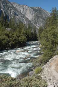 asleep quickly each night.
The canyon is very deep at this point - perhaps 4,000 feet or more. Unlike Yosemite Valley, the canyon here is "V" shaped, created mostly by the cutting erosive action of streams, though there are plenty of sheer rock faces which certainly were scraped and formed by glacial action 25,000 years ago or more. The river flows thru rapids almost everywhere, with few calm spots, and takes on a light green color from the air which is intermixed as the river churns over the rocks.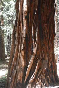
Our third day of hiking takes us to Pate Valley, an unpreposessing trail junction in deep woods. On our way there we pass thru a grove of tall trees, probably Giant Sequoias, certainly over 100 feet tall, and with diameters of maybe 10 feet. These trees, with shaggy red bark, stand out from the pines and a few oaks which are intermixed here. In the High Sierra (above 8,000 feet) there are mostly needles on the ground, but here we enter forested areas where dry dead oak leaves predominate on the trail, sometimes making it hard to find. It's at this spot where Jason, walking blithely along the trail, spots a snake crossing in fromt of him, and realizes it's a rattlesnake. Never having seen one, I'm curious but cautious. This one has taken refuge by coiling in a bush a few feet off the trail. He's more interested in getting out of our way than in threatening us. We pass by.
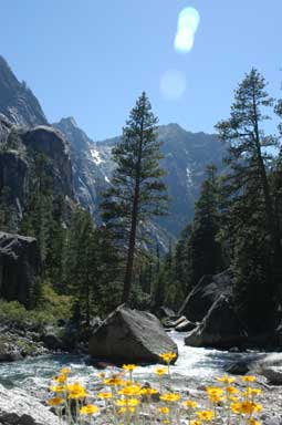 The canyon is filled with spring and early-summer wildflowers at places, and the type of flowers changes as our elevation changes. There are a few butterflies flitting around as well. In fact, it's while I'm trying to shoot some pictures of butterflies that I spot the giant redwoods!
We reach Pate Valley, where trails branch, and see pretty much the only hiker we spot today, going the opposite direction as we cross two wooden bridges getting us to the opposite site of the Tuolumne River. What a great place this would be to camp. We stop for a few minutes to snack. Clark has brought a bit too much trail mix and we help him reduce the weight of his pack a bit. Some places we find tree stumps conveniently cut off to sit on, like a private picnic ground, but at this particular location, Clark and Jason take their bear cans out and sit on them. A great spot to relax for a few minutes before heading uphill. Yes, uphill is what I said. At this point we had a big decision to make - we know we have 4,000 feet of uphill ahead of us before we're out of the canyon, so we take a look at the map and decide that since it's still early in the afternoon, we'll try to do 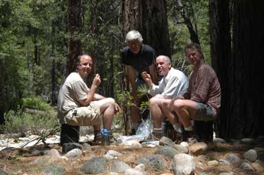 2,000 feet of the climb today, and camp overnight halfway up the side of the canyon. Looks pretty doable on the map. So up we go. The trail ascends the side of the canyon by paralleling a stream which comes down from above. The trail is cut as a series of switchbacks - seems like hundreds of them - and is moderaly steep in many places. By late afternoon we've reached a great camping spot, with no evidence of its having been used yet this year by anyone else, and with a great view of the Hetch Hetchy reservoir, which is the destination of all the water in the river. The Hetch Hetchy is the catch-water for all of San Francisco, and the water goes via aqueduct for hundreds of miles to serve the needs of the city. We fix dinner, and then relax on the rocks overlooking the
 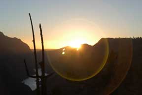 reservoir as the sun sets.
We've decided to get an early start the final morning so we can make the last half of the ascent before the sun makes it too hot. This time of year isn't beastly hot, but it's still rough when you're climbing so many vertical feet. So our crew is up at 5:30, just as the sun breaks the horizon, and on the trail by 6:30. A bit early for my taste, but tolerable. Sunrise hits the various peaks at different times, causing the light patterns to change from minute to minute. The sky is reflected in the Hetch Hetchy reservoir, which continues to be visible for some hours as we climb upward.
By early afternoon we have reached our destination, known as White Wolf, fully 30 miles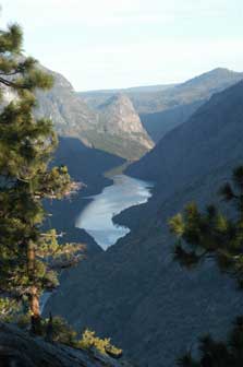 from our entry point at Glen Aulin. (We left Jeff's car there, so he and Jason run a car-bridge to pick up my car from Glen Aulin and return for the drive to San Francisco.)
 We made it thru this 30-mile warm-up trip with no disasters, and only a few mosquitoes. Nobody fell in the river, or even got wet, except for swimming along the way. No intense heat. And no rain. Looks like this has been a great prelude to a great summer of hiking in the Yosemite backcountry, with two more trips planned for the season.
![]()